
 In 2001, a map was created of the above-ground and underwater landscapes and archaeological sites of Rainsford Island, one of the 34 islands located in Boston Harbor, Massachusetts. The project was conducted by the Institute of Maritime History (IMH) with support of the Center of Coastal and Ocean Mapping (CCOM) and sponsored by the Boston Landmarks Commission (BLC) and the Massachusetts Historical Commission (MHC). The purpose of the mapping survey was to determine the impact of human actions and natural factors on the island’s historic and prehistoric archaeological sites. As the managers of Rainsford Island, the BLC commissioned this survey in order to determine if the island is suitable for public uses such as education, recreation, and scientific research. The BLC also would use the survey findings to develop a long-term management and preservation plan for the island’s cultural and natural resources.
Geography
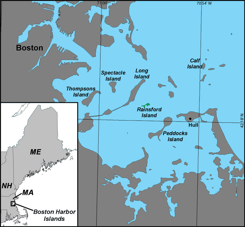
Rainsford Island is located in Boston Harbor, half-way between the town of Hull and the City of Boston. The island is approximately 11 acres in area and, like other Boston Harbor Islands, consists of a mound of glacially-deposited rock and dirt called a drumlin. The top of the drumlin is the island’s highest point: 16.7 m above Mean Sea Level (MSL). The island is partially encircled along its eastern side by a large granite seawall. The western half of the island is made up of a number of interspersed rock outcrops, which is joined to the drumlin by a narrow spit of sand and gravel. Extensive erosion caused by winds and waves and centuries of land modification have significantly altered the shape of the island.
 Prehistory
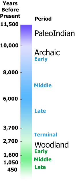
Approximately 60 prehistoric sites have been documented on the Boston Harbor Islands, suggesting that Rainsford Island could have been occupied or visited during this time. On Long Island, an Early Archaic-Period projectile point marks the earliest evidence of human activity in the islands. During the Late Archaic Period (5,000 BP [Before Present]) to the Late Woodland Period (400 BP), the most common prehistoric sites amongst the islands are shell middens, but some burials also took place during the Archaic Period. Late Woodland Period sites are located on the outer harbor islands as well, which may suggest early contact and trade with European fishermen and explorers. No prehistoric archaeological sites were located during the 2001-2002 survey of Rainsford Island.
A Brief History
 The purchase of Rainsford Island in 1636 by Edward Raynsford brought to the island its first European inhabitants. Early deeds and Massachusetts Bay Colony papers indicate that throughout the 17th and early 18th centuries Rainsford Island was used as a fishing station, a cattle pasture, and as a source for timber and slate. In 1736, the Province of Massachusetts purchased the island, and the following year the quarantine station for vessels wishing to enter the port of Boston moved to Rainsford Island from Spectacle Island.
In the 1770s, small pox inoculations were first given on Rainsford Island. Dr. John Jeffries, the quarantine physician at the time, inoculated his own son in 1775 with calf pox, more than 20 years before Edward Jenner demonstrated the effectiveness of variolation in 1796. Rainsford Island’s role as a quarantine station continued throughout the early 19th century, and its limited resources were pressed as more and more vessels entered the busy port of Boston, carrying various diseases.
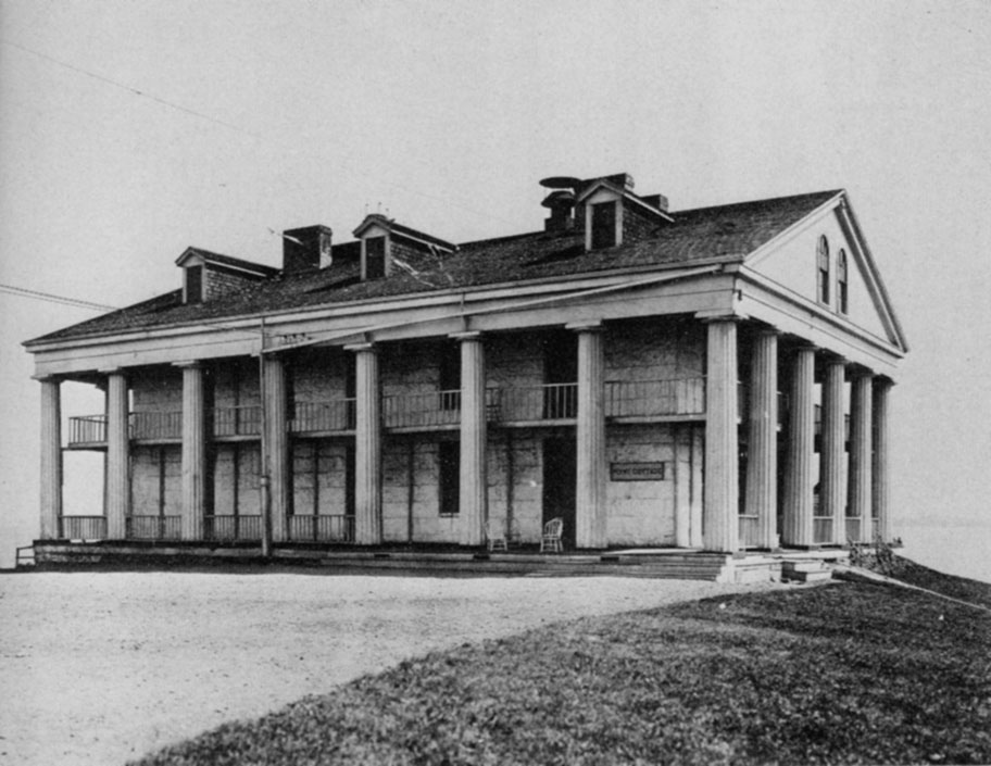
During the first half of the 19th century, the hospital facilities were expanded and improved. A massive Greek Revival-style building, called the Stone Hospital or Greek Temple, was built in 1832 by Josiah Rogers. The Stone Hospital was in all likelihood designed by his brother, the American architect Isaiah Rogers, renowned for his designs of the Boston and New York Merchants’ Exchange, the U.S. Treasury Building in Washington, D.C., and the Tremont Hotel in Boston.
In the second half of the 19th century, the island continued as a place of quarantine, but the facilities increasingly doubled as an almshouse for Civil War veterans. A 3-story brick structure known as the House of Reformation was built during 1890s, which was meant to isolate Boston’s unwanted young boys and keep them working industriously in the island’s print, shoe and garment shops, and in farming and raising livestock. In the early 20th century, the House of Reformation was renamed the Suffolk School for Boys. It continued to serve as an almshouse into the 1920s, until the increasing financial woes of the Great Depression led to the school’s demise and ultimately the island’s abandonment.
 Methods of the Survey
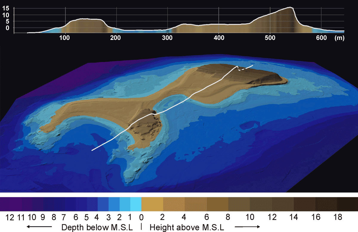
Rainsford Island was surveyed in 2001-2002 using a combination of remote sensing and standard archaeological survey techniques. Reconnaissance work included a marine survey of the shallow waters around Rainsford using a Reson multibeam sonar, and aerial photographs of the island were taken in the spring of 2002 at low tide. A side-scan sonar survey of the island’s waters (up to ca. -20 meters MSL) was also performed by NOAA Ship Whiting. From the aerial photographs, 1-foot contour lines, vegetation coverage as well as exposed architecture and archaeological features were mapped using digital stereoplotting instruments. A seamless Digital Elevation Model (DEM) was created by fusing the high-resolution, low-altitude aerial photography and multibeam sonar data.
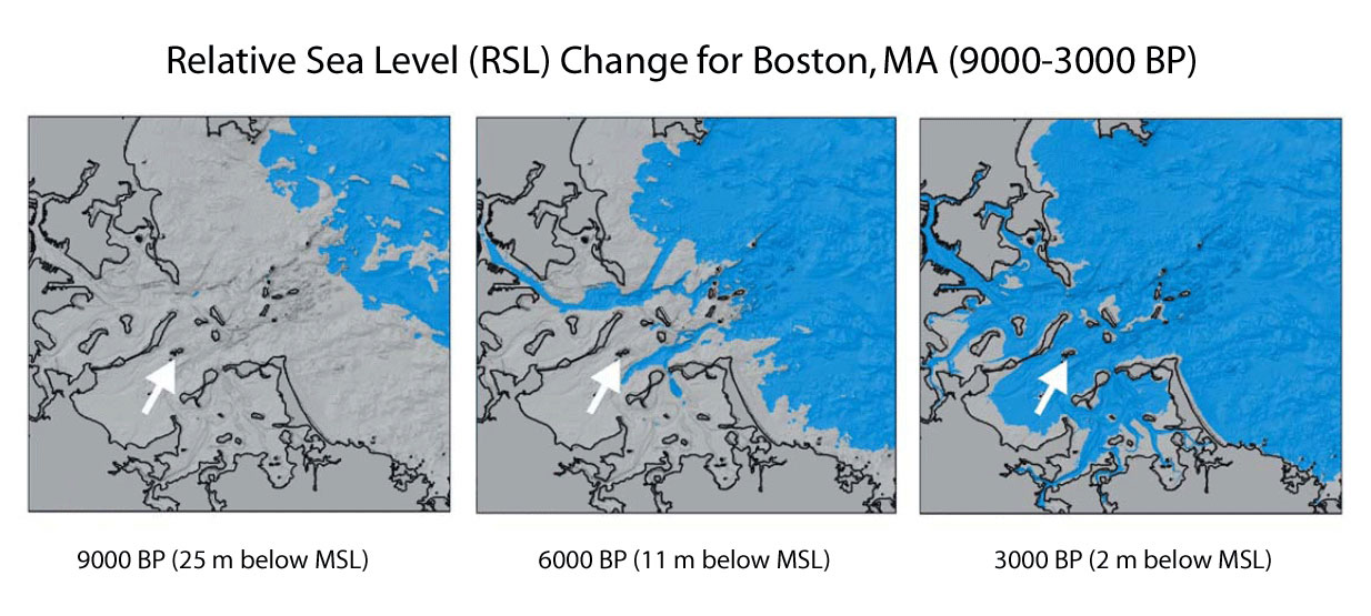
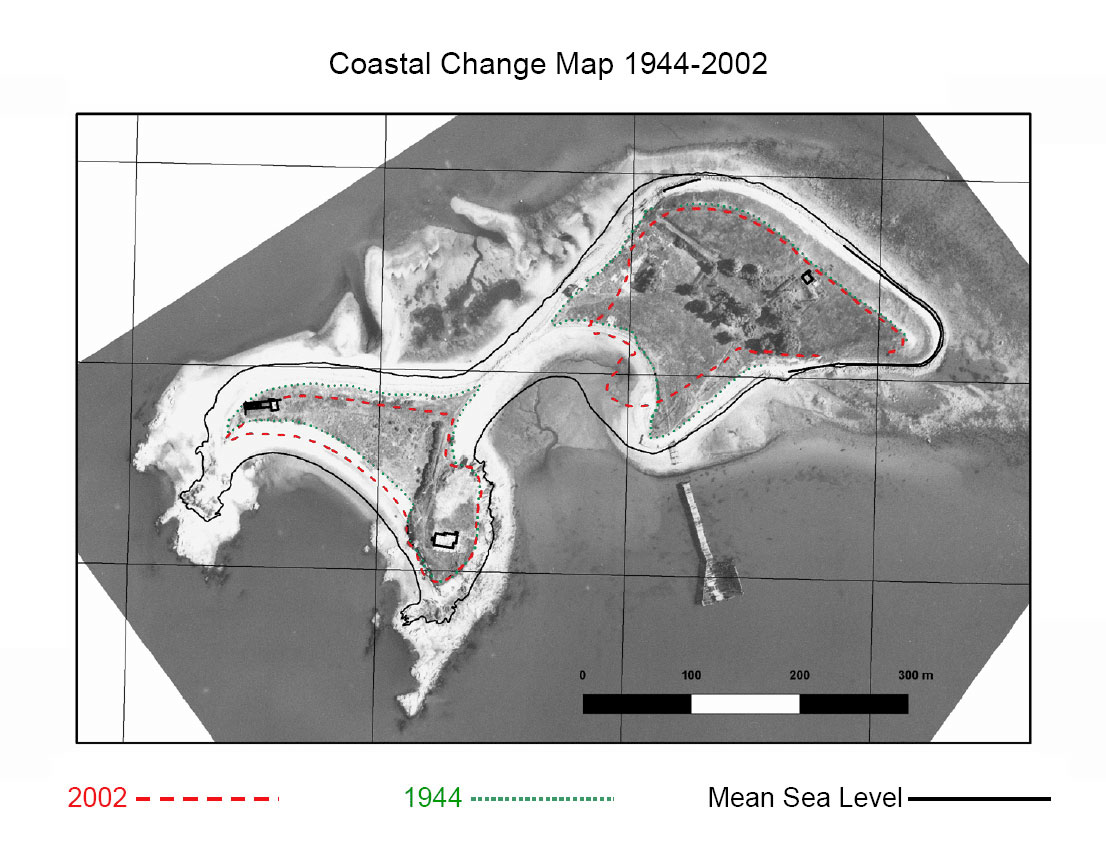 A walkover survey was conducted to locate archaeological sites and features, which were plotted using a Global Positioning System (GPS) receiver. Archaeological test pits were also excavated on the island and numerous historic-period archaeological sites were discovered. (coastal change image) The study also utilized aerial photographs taken in the early 20th century to illustrate the island’s changing coastal environment. All the information was combined in a Geographic Information System (GIS) in order to develop predictive models and maps that identified the known and probable locations of archaeological resources, both prehistoric and historic. In addition, the data derived from the research project was used to model ancient shorelines. (sea level change image) The GIS maps and data provide a context for determining areas of environmental and archaeological sensitivity.
Summary
The archaeological survey of Rainsford Island used low-impact, remote-sensing techniques that offered significant insight into the dynamic environment of a part of Boston Harbor. High-resolution maps provided coastal resource managers with the spatial information needed for informed decision-making and preservation planning. The survey also provided the Boston Landmarks Commission with critical data from which future archaeological research and education programs can proceed. A survey report on this project by the Institute of Maritime History is available on request from the Massachusetts Historical Commission or the Boston Landmarks Commission.
Acknowledgements and Links
- Ellen Berkland, Boston City Archaeologist, Boston Landmarks Commission
- Elizabeth Carella, Archives For Historical Documentation
- Institute of Maritime History
- Lloyd Huff and Martin Jakobsson, Center for Coastal and Ocean Mapping (UNH)
- NOAA Ship Whiting
- United States Coast Guard, Point Allerton (Hull, MA)
- Reson, Inc.
- Boston Harbor Police
- Massachusetts Historical Commission
Stefan Claesson was the Principal Investigator of the Rainsford Island Archaeological Survey and author of this page.