
Another crewmember has arrived on the 9th of July. Norine Carroll is a volunteer who I have worked with on a number of shipwreck projects since 1997. She currently works in the Smithsonian in Washington D.C., and has agreed to come for two weeks to work with us. Norine is an archaeological conservator, which means her specialty is the treatment and stabilization of artifacts, and she is also an accomplished diver and archaeologist as well. Norine has worked on a wide variety of shipwrecks in Turkey, Jamaica, the Dominican Republic, Texas, and elsewhere. Norine was also one of the first participants in the original St. Augustine Shipwreck Survey, a project in Florida that led to the formation of LAMP, one of the research institutes sponsoring the Achill Island Maritime Archaeology Project.
Since we are coming to Westport to pick up Norine at the bus station, we plan to stay for a few days at our friends the Shanleys, and spend some time documenting the unknown wreck at Westport Quay. We spend two days mapping the layout and hull remains of this wreck. The first day it is just Kevin and myself, as Norine needs to sleep off her jetlag, but she joins us on the following day.
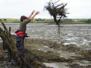
The Westport Quay wreck is on the foreshore, which means it is totally exposed during low tide. We have borrowed a small boat from a local Westport man so that we can drive from the quay to a point close to the wreck, and we walk out the rest of the way. The first task is to strip the wreck of the large masses of kelp which grow on its timbers.
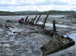
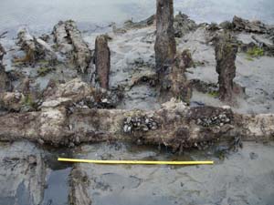
Once the kelp is removed, the portion of the shipwreck protruding from the sediment is exposed, and we can better understand its basic layout. We can now distinguish the bow end from the stern end. Here we see the wreck from bow (foreground) to stern (background).
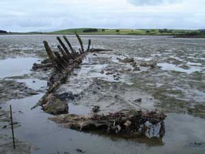
Its total length is about 65 feet, and it is listing sharply to the port side. In this picture the stern is in the foreground.
One of our first tasks now that we can clearly observe features on the wreck is to count and number the frames or “ribs” of the vessel. We have been able to identify at least thirty sets of frames. Frames are the thick, curved timbers that give the hull its U-shape. Frames are made up of floor timbers, which were laid over the keel and extend outwards on either side, and futtocks, which are attached to the floors and form the upward-curving sides of the ship. We have examples of both preserved on this wreck. Here Norine is preparing to tag each frame pair with pre-assigned numbers from bow to stern. This will help orient ourselves to the wreck site and aid our analysis of the hull remains.
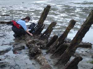
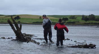
Another important structural timber we have identified is the keelson. This longitudinal timber spans the entire length of the ship, positioned in the center of the vessel over the floor frames. It sandwiched the frames beneath it with the keel of the ship below, forming a strong framework necessary for a seagoing vessel. It can be seen in the picture above under Norine’s knees, where it runs over the frames. In the image below, Norine and Kevin are recording the position of the keelson by taking offset measurements from a central baseline which we have suspended across the entire length of the wreck near its centerline.
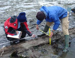
These measurements will later be used to plot the position of the keelson, other hull timbers, and scattered artifacts onto a master site plan.
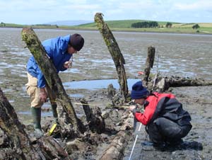
Norine and Kevin measuring the position of a frame towards the stern in relation to the central baseline.
While Norine and Kevin are focusing on mapping the frames, Chuck is concentrating on recording the position and details of the keelson. A number of interesting features are observed, including the mast step, seen below. This large block of wood bolted to the keelson featured a mortise or hole, into which the heel of the mast was placed.
We only have several hours of work time before the tides begin to rise. Chuck and Norine, who are waterproof in their drysuits, take a few final measurements before the wreck is once again covered up by the sea.
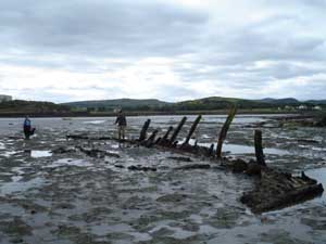
Chuck is at the helm as the crew makes the return trip from the wreck to the quay. After two days of mapping, we have recorded the position of every frame, of the keelson, and the outline of the bow and stern assemblies. Future objectives include recording the scatter of ballast stones and ships fittings, recording specific dimensions of key structural timbers, and recording a profile of various frames to help reconstruct the original shape of the vessel. But for now we are preparing to return for Achill, where we will be spending more time on the curragh pens, recording anchors, and preparing for diving operations set to start when our fourth team member Sam arrives next week.
